Grid developed for Broad-scale gridding in the Georges Bank and Gulf of Maine area (GB project)
Project
Program
| Contributors | Affiliation | Role |
|---|---|---|
| Wiebe, Peter H. | Woods Hole Oceanographic Institution (WHOI) | Principal Investigator |
| Groman, Robert C. | Woods Hole Oceanographic Institution (WHOI BCO-DMO) | BCO-DMO Data Manager |
Abstract
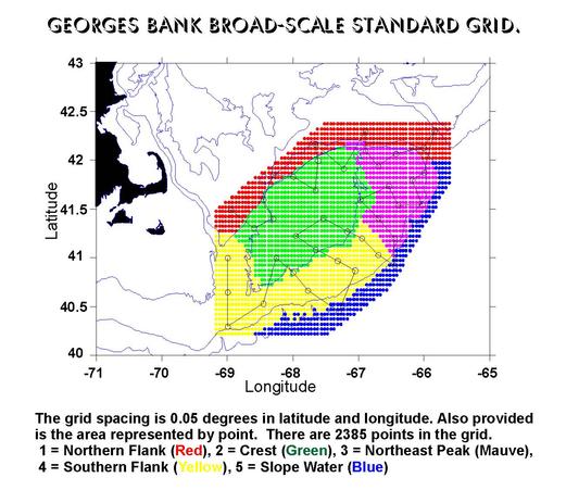
The Broad-scale grid is defined by the points within this data file. It is used for Broad-scale gridding applications. Each rectangle in the grid is 0.05 degrees latitude by 0.05 degrees longitude. The area is the area, in km2, that the grid point represents. The field names are as follows:
For information relating to the development of the grid, see the Grid Report
This is an example of a gridding datasheet.
Download Excel File. (Hold SHIFT key and Click to download)
Note: Subregion 5 (Slope Water) has been redefined to include those points formerly in Subregion 3 (Northeast Peak) where the water is deeper than 150 meters.
Last modified: June 16, 2004
| File |
|---|
broadscale_grid.csv (Comma Separated Values (.csv), 76.73 KB) MD5:b97314304198a56844f95fb9d7a2b766 Primary data file for dataset ID 2296 |
| Parameter | Description | Units |
| lon | longitude | decimal degrees, negative is west |
| lat | latitude | decimal degrees |
| area | area | km<sup>2</sup> |
| depth_w | water depth | meters |
| grid | grid number | numeric value from 1 to 2385 |
| subregion | subregion for each grid point | numeric value from 1 to5 |
U.S. GLOBEC Georges Bank (GB)
The U.S. GLOBEC Georges Bank Program is a large multi- disciplinary multi-year oceanographic effort. The proximate goal is to understand the population dynamics of key species on the Bank - Cod, Haddock, and two species of zooplankton (Calanus finmarchicus and Pseudocalanus) - in terms of their coupling to the physical environment and in terms of their predators and prey. The ultimate goal is to be able to predict changes in the distribution and abundance of these species as a result of changes in their physical and biotic environment as well as to anticipate how their populations might respond to climate change.
The effort is substantial, requiring broad-scale surveys of the entire Bank, and process studies which focus both on the links between the target species and their physical environment, and the determination of fundamental aspects of these species' life history (birth rates, growth rates, death rates, etc).
Equally important are the modelling efforts that are ongoing which seek to provide realistic predictions of the flow field and which utilize the life history information to produce an integrated view of the dynamics of the populations.
The U.S. GLOBEC Georges Bank Executive Committee (EXCO) provides program leadership and effective communication with the funding agencies.
U.S. GLOBal ocean ECosystems dynamics (U.S. GLOBEC)
U.S. GLOBEC (GLOBal ocean ECosystems dynamics) is a research program organized by oceanographers and fisheries scientists to address the question of how global climate change may affect the abundance and production of animals in the sea.
The U.S. GLOBEC Program currently had major research efforts underway in the Georges Bank / Northwest Atlantic Region, and the Northeast Pacific (with components in the California Current and in the Coastal Gulf of Alaska). U.S. GLOBEC was a major contributor to International GLOBEC efforts in the Southern Ocean and Western Antarctic Peninsula (WAP).
| Funding Source | Award |
|---|---|
| National Science Foundation (NSF) | |
| National Oceanic and Atmospheric Administration (NOAA) |
[ table of contents | back to top ]