Zooplankton abundance and stages from MOCNESS nets from the RVIB Nathaniel B. Palmer from the Southern Ocean, 2001-2002 (SOGLOBEC project, Southern Ocean Krill project)
Project
Programs
| Contributors | Affiliation | Role |
|---|---|---|
| Ashjian, Carin J. | Woods Hole Oceanographic Institution (WHOI) | Principal Investigator |
| Wiebe, Peter H. | Woods Hole Oceanographic Institution (WHOI) | Principal Investigator |
| Copley, Nancy | Woods Hole Oceanographic Institution (WHOI) | Technician, BCO-DMO Data Manager |
Abstract
Zooplankton Abundance Based on Taxa and Life Stages or Size Classes, Collected during the Broadscale NB Palmer Cruises, Austral Autumn 2001 and 2002
The MOCNESS-1 plankton sampler has nine rectangular nets (1m x 1.4 m) with a mesh size of 0.333 mm, which are opened and closed sequentially by commands through conducting cable from the surface (Wiebe et al., 1976).
Note: NBP0104 tows 1-11 used a 500 micron mesh for net 1 samples. Then it was moved to net 0 for the remainder of tows.
Cruises:
Nathaniel B. Palmer, April-June 2001 (NBP01-03), 24 tows
Nathaniel B. Palmer, July-Sept. 2001 (NBP01-04), 17 tows
Nathaniel B. Palmer, April-May 2002 (NBP02-02), 24 tows
Nathaniel B. Palmer, July-Sept. 2002 (NBP02-04), 19 tows
Related datasets:
Zooplankton biovolume values from MOCNESS tows - this data set is derived from displacement volume measurements and dry weight conversion calculations from the same set of samples as the above data. globec.whoi.edu/jg/serv/globec/soglobec/mocness_biovols_rs.html0
Zooplankton Abundance and biomass from MOCNESS nets using silhouette analysis
NB Palmer, austral fall & winter of 2001 & 2002 - Biomass (wet weight) and abundance were determined principally by silhouette digitization of taxa lengths and conversion to equivalent wet weights according to the equations and methods adapted from Davis and Wiebe (1985) and Wiebe et al. (2004). globec.whoi.edu/jg/serv/globec/soglobec/zoo_moc.html0
Contact Information:
Net sample collections: Carin Ashjian, Peter Wiebe, Nancy Copley, Phil Alatalo at Woods Hole Oceanographic Inst.
Sample Analyses: Atlantic Reference Centre (ARC, www.huntsmanmarine.ca/arc.shtml), located in St. Andrews, New Brunswick, Canada under the supervision of Dr. Gerhard Pohle.
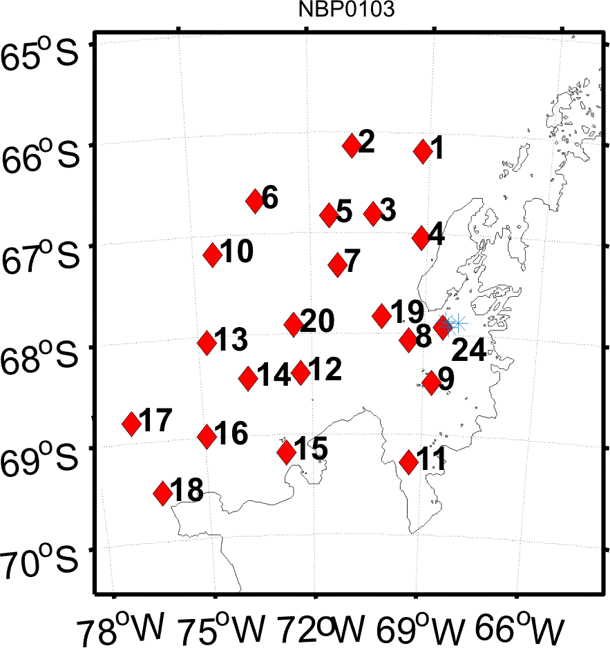
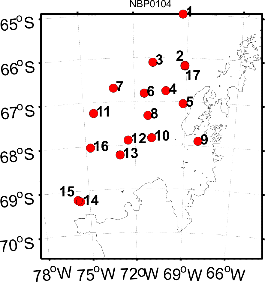
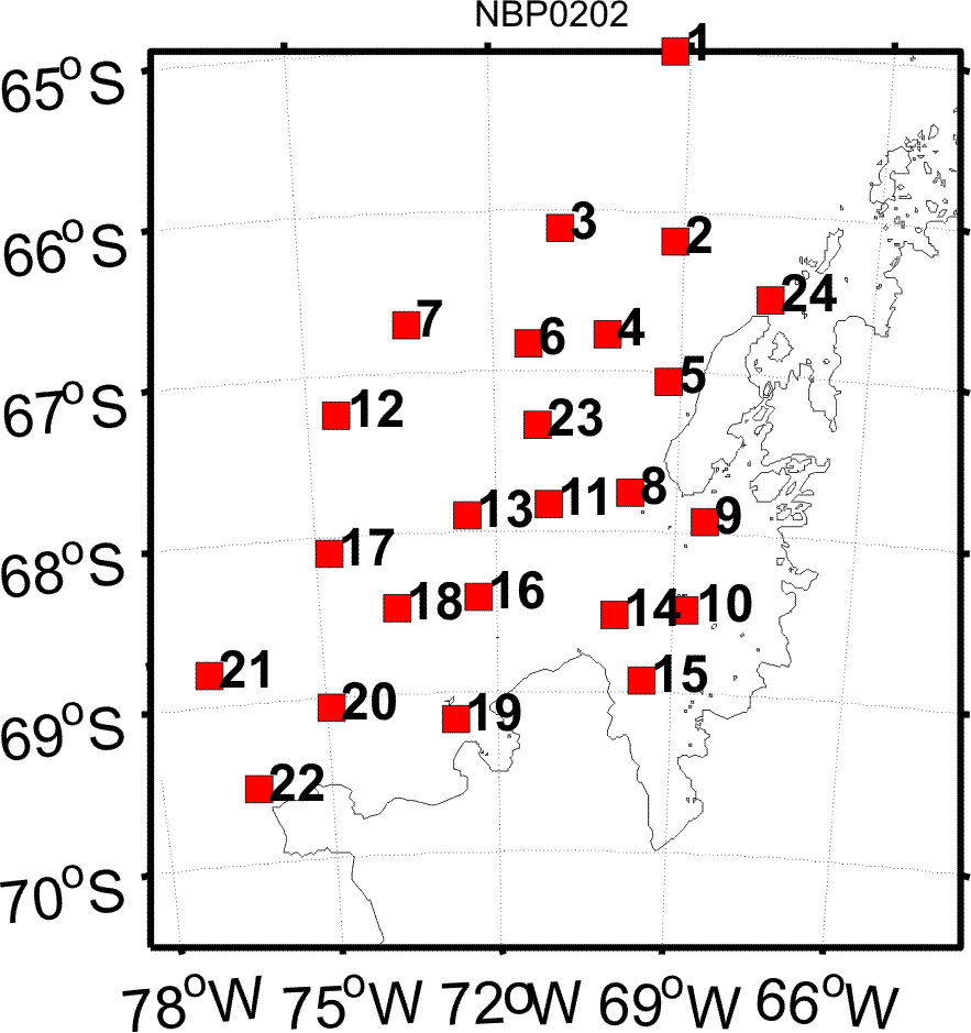
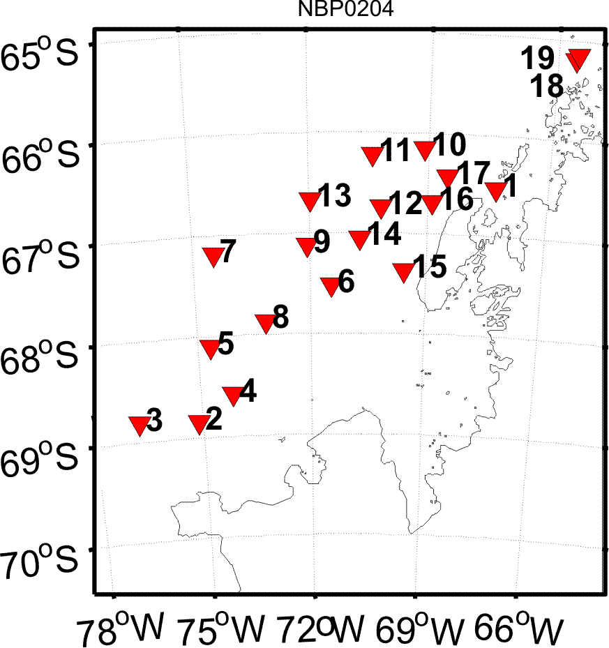
Zooplankton abundance, vertical and horizontal distribution, and population structure were assessed using a 1 m^2 Multiple Opening and Closing Nets and Environmental Sampling System (MOCNESS) with nine nets having 333 um mesh and environmental sensors of temperature, salinity and depth. The entire water column was sampled on the downcast using net # 0, which was not analyzed here. The water column was typically sampled from close to the bottom at stations on the shelf where depths were less than 1000 m, or to 1000m at stations off the shelf where depths were often from 3000 to 4000 m. Nets 1 through 8 sampled from various depth intervals to the surface with smaller strata near the surface. Several tows targeted krill swarms by towing in a single strata. Approximate locations of broadscale study stations are shown in Figs. 1-4, below.
Zooplankton samples were immediately preserved in 5% buffered formalin solution. In 2006, the samples were sent to the Atlantic Reference Centre, Huntsman Marine Science Centre, St. Andrews, New Brunswick, Canada to be sorted. All the large organisms (>15 mm) in the sample were removed and identified to taxa. The sample was then split to about 100 individuals of euphausiids. All euphausiids in the split were identified to species and life history stage. Next, the sample was split to about 100 individuals of copepods. Copepods were identified to species and life history stage (female, male, copepodite V, or other copepodite). All other zooplankton in the split were identified to taxa and counted. For the Euchaetidae, we followed the designation of Park (1994) who ascribed the Antarctic species to the genus Paraeuchaeta. This data object ('zooabund_nbp') reports the counts of zooplankton per subsample/split by taxa and life stage or size class. The companion data object 'zooabund_lmg' reports similar for the MOCNESS samples collected on the L.M. Gould cruises and data object 'krill' reports the abundance of each euphausiid species by life stage and size class, also on the L. M. Gould.
Displacement volume measurement:
Entire sample plus liquid was measured in a large graduated cylinder then poured through a sieve into a second cylinder. The difference in volume is the displacement volume.
Greenwich Mean Time was local time + 4 hours.
Fig. 1. NBP-0103: Locations for the oblique MOCNESS tows taken in austral fall 2001 as part of the broad-scale survey (solid dots) and the horizontal tows taken in krill patches in Marguerite Bay (asterisks).
Fig. 2. NBP-0104: Locations for the oblique MOCNESS tows taken in austral winter 2001 as part of the broad-scale survey.
Fig. 3. NBP-0202: Locations for the oblique MOCNESS tows taken in austral fall 2002 as part of the broad-scale survey.
Fig. 4. NBP-0204: Locations for the oblique MOCNESS tows taken in austral winter 2002 as part of the broad-scale survey.
| File |
|---|
zooabund_nbp.csv (Comma Separated Values (.csv), 2.19 MB) MD5:9b68dc73a3cb80307d53bb643098a8fd Primary data file for dataset ID 2387 |
| Parameter | Description | Units |
| cruiseid | Cruise identifier (NBP0103, NBP0104, NBP0202, NBP0204) | |
| year | Year of cruise | |
| station | Station number or designation (e.g. MB = Marguerite Bay) | |
| tow | Net tow number | |
| month_local | Month of year, local time | |
| day_local | Day of month, local time | |
| time_local | Time local, GMT = local time +4 hours | HHmm |
| event | Event number from cruise event log; unique ID | |
| lat | Latitude at beginning of net tow, negative = South | decimal degrees |
| lon | Longitude at beginning of net tow, negative = West | decimal degrees |
| depth_w | Depth of water | meters |
| region | Geographic region | |
| yrday_local | local day and decimal time, as 326.5 for the 326th day of the year, or November 22, at 1200 hours (noon) | |
| net | Net number | |
| depth_open | Depth each net was opened | meters |
| depth_close | Depth each net was closed | meters |
| depth_mid | Mid-depth of strata that each net sampled | meters |
| vol_filt | Volume of water filtered by each net | meters<sup>3</sup> |
| displ_vol | Sample displacement volume1 (biovolume) | milliliters |
| taxon_group | Taxonomic group (Euphausiids, Copepods, Other Zooplankton) | |
| taxon | Scientific name of organism or common name of group | |
| stage | Life history stage, size class or gender e.g.: | |
| abundance | Density of individuals within stage/size interval. Calculated as: | number per meter<sup>3</sup> |
| comments | comments pertaining to the taxon in the record | unitless |
| Dataset-specific Instrument Name | MOCNESS1 |
| Generic Instrument Name | MOCNESS1 |
| Dataset-specific Description | The MOCNESS-1 plankton sampler has nine rectangular nets (1m x 1.4 m) with a mesh size of 0.333 mm, which are opened and closed sequentially by commands through conducting cable from the surface (Wiebe et al., 1976). |
| Generic Instrument Description | The Multiple Opening/Closing Net and Environmental Sensing System or MOCNESS is a family of net systems based on the Tucker Trawl principle. The MOCNESS-1 carries nine 1-m2 nets usually of 335 micrometer mesh and is intended for use with the macrozooplankton. All nets are black to reduce contrast with the background. A motor/toggle release assembly is mounted on the top portion of the frame and stainless steel cables with swaged fittings are used to attach the net bar to the toggle release. A stepping motor in a pressure compensated case filled with oil turns the escapement crankshaft of the toggle release which sequentially releases the nets to an open then closed position on command from the surface. -- from the MOCNESS Operations Manual (1999 + 2003). |
NBP0103
| Website | |
| Platform | RVIB Nathaniel B. Palmer |
| Report | |
| Start Date | 2001-04-24 |
| End Date | 2001-06-05 |
NBP0104
| Website | |
| Platform | RVIB Nathaniel B. Palmer |
| Report | |
| Start Date | 2001-07-22 |
| End Date | 2001-08-31 |
NBP0202
| Website | |
| Platform | RVIB Nathaniel B. Palmer |
| Report | |
| Start Date | 2002-04-09 |
| End Date | 2002-05-21 |
NBP0204
| Website | |
| Platform | RVIB Nathaniel B. Palmer |
| Report | |
| Start Date | 2002-07-31 |
| End Date | 2002-09-18 |
| Description | Also see NBP0204 Cruise Data Report |
U.S. GLOBEC Southern Ocean (SOGLOBEC)
The fundamental objectives of United States Global Ocean Ecosystems Dynamics (U.S. GLOBEC) Program are dependent upon the cooperation of scientists from several disciplines. Physicists, biologists, and chemists must make use of data collected during U.S. GLOBEC field programs to further our understanding of the interplay of physics, biology, and chemistry. Our objectives require quantitative analysis of interdisciplinary data sets and, therefore, data must be exchanged between researchers. To extract the full scientific value, data must be made available to the scientific community on a timely basis.
GLOBEC: Winter Distribution and Success of Southern Ocean Krill (Southern Ocean Krill)
The U.S. Global Ocean Ecosystems Dynamics (U.S. GLOBEC) program has the goal of understanding and ultimately predicting how populations of marine animal species respond to natural and anthropogenic changes in climate. Research in the Southern Ocean (SO) indicates strong coupling between climatic processes and ecosystem dynamics via the annual formation and destruction of sea ice. The Southern Ocean GLOBEC Program (SO GLOBEC) will investigate the dynamic relationship between physical processes and ecosystem responses through identification of critical parameters that affect the distribution, abundance and population dynamics of target species. The overall goals of the SO GLOBEC program are to elucidate shelf circulation processes and their effect on sea ice formation and krill distribution, and to examine the factors which govern krill survivorship and availability to higher trophic levels, including penguins, seals and whales. The focus of the U.S. contribution to the international SO GLOBEC program will be on winter processes. This component will focus on juvenile and adult krill and mesozooplankton prey distribution and abundance using a sophisticated instrument package, BIOMAPPER II, which is equipped with an acoustic backscatter sonar system, a video plankton recorder and an environmental sensor system. The system is used in large-scale studies. Additionally, a remotely-operative vehicle will be used to map the distribution and behavior of krill under ice. The result of the integrated SO GLOBEC program will be to improve the predictability of living marine resources, especially with respect to local and global climatic shifts.
U.S. GLOBal ocean ECosystems dynamics (U.S. GLOBEC)
U.S. GLOBEC (GLOBal ocean ECosystems dynamics) is a research program organized by oceanographers and fisheries scientists to address the question of how global climate change may affect the abundance and production of animals in the sea.
The U.S. GLOBEC Program currently had major research efforts underway in the Georges Bank / Northwest Atlantic Region, and the Northeast Pacific (with components in the California Current and in the Coastal Gulf of Alaska). U.S. GLOBEC was a major contributor to International GLOBEC efforts in the Southern Ocean and Western Antarctic Peninsula (WAP).
| Funding Source | Award |
|---|---|
| NSF Antarctic Sciences (NSF ANT) | |
| NSF Antarctic Sciences (NSF ANT) |
[ table of contents | back to top ]


