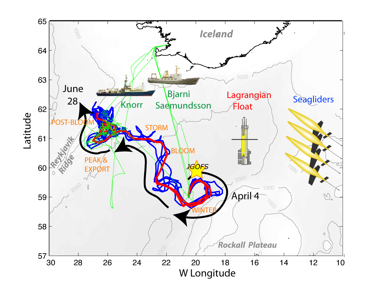
Cruise track data from ship underway data acquisition system from cruises KN193-03, B4-2008, B9-2008,and B10-2008 in the subpolar North Atlantic and Iceland Basin in 2008 (NAB 2008 project)
Project
Program
| Contributors | Affiliation | Role |
|---|---|---|
| D'Asaro, Eric | University of Washington Applied Physics Laboratory (UW APL) | Principal Investigator |
| Perry, Mary Jane | University of Maine (U Maine DMC) | Principal Investigator |
| Lee, Craig M. | University of Washington Applied Physics Laboratory (UW APL) | Co-Principal Investigator, Co-Principal Investigator |
| McKee, Theresa | Woods Hole Oceanographic Institution (WHOI BCO-DMO) | BCO-DMO Data Manager |
Cruise Tracks (time and position) recorded by Global Positioning System.
| File |
|---|
cruiseTrack.csv (Comma Separated Values (.csv), 1.10 MB) MD5:266e756b190c8702c6d8080aab51fbba Primary data file for dataset ID 3385 |
| Parameter | Description | Units |
| Cruise_ID | Cruise_ID | dimensionless |
| date | date (UTC) as YYYYMMDD | dimensionless |
| time | time (UTC) as HHMM | dimensionless |
| latitude | latitude (positive is North) | decimal degrees |
| longitude | longitude (negative is West) | decimal degrees |
| seafloor | depth of water as reported by ship's 12 KHz Knudsen echosounder | meters |
| julian_day_yr0 | year day | dimensionless |
| Dataset-specific Instrument Name | Echo sounder - single-beam |
| Generic Instrument Name | Echo sounder - single-beam |
| Dataset-specific Description | Knudsen Engineering Model 320BR
sub-bottom profiler, echosounder
operating at 12 kHz |
| Generic Instrument Description | A single-beam echo sounder is an instrument that measures water depth at a single point below the platform by timing pulses of sound reflected on the seafloor. The echo sounder transmits and receives sound, accurately measuring the time it takes to leave the sounder, reach the bottom and return to the sounder. It then converts this information into digital or graphic representations of the bottom depth and relief.
The average echo sounder consists of a transmission and reception unit that sends sound signals through the water, receives and decodes information and converts that information into either a graphic or visual form. Attached to the receiver is a transducer that acts as a microphone and a speaker under the water. Sound waves travel at approximately 1500 m/s through the water dependent on water temperature". more from LMS Technologies |
| Dataset-specific Instrument Name | Global Positioning System Receiver |
| Generic Instrument Name | Global Positioning System Receiver |
| Dataset-specific Description | C-Nav Real Time Gypsy (RTG) GPS
Northstar 941XD GPS with differential capability
Trimble Tasman P(Y) P-Code GPS
(2) Furuno GP-90D WAAS/dGPS
Furuno GP1850-WD WAAS/dGPS |
| Generic Instrument Description | The Global Positioning System (GPS) is a U.S. space-based radionavigation system that provides reliable positioning, navigation, and timing services to civilian users on a continuous worldwide basis. The U.S. Air Force develops, maintains, and operates the space and control segments of the NAVSTAR GPS transmitter system. Ships use a variety of receivers (e.g. Trimble and Ashtech) to interpret the GPS signal and determine accurate latitude and longitude. |
KN193-03
| Website | |
| Platform | R/V Knorr |
| Start Date | 2008-05-01 |
| End Date | 2008-05-22 |
| Description | A three-week process cruise on the R/V Knorr operated in the vicinity of five autonomous platforms that had been deployed in early April by another vessel. A total of 10 simultaneous float and CTD calibration profiles were taken to calibrate sensors on the Lagrangian mixed layer float (Biofloat 48) and to validate proxy measurements (i.e., optical attenuation to particulate organic carbon, etc.). One simultaneous Seaglider and CTD calibration profile was collected for each of the four Seagliders. Knorr also carried out a number of bow-tie surveys around the Lagrangian mixed layer float. A second float, Biofloat 47, had ceased functioning shortly after deployment was rescued at the beginning of the cruise. Two SOLOPC floats were deployed but were damaged on deployment and sank. A number of successful short deployments of PELAGRA floating were made during the cruise.
Core ship-board measurements supported by project funding were: 1) CTD profiles (temperature, conductivity, oxygen, chlorophyll fluorescence, optical backscatter, and beam transmission) on all four cruises; 133 CTD profiles were obtained on this cruise. 2) analysis of water samples collected with the CTD Rosette (chlorophyll, HPLC pigments, nutrients, particulate organic carbon, particulate absorption spectrum, phytoplankton, oxygen and other guest investigator measurements).
Original cruise data are available from the NSF R2R data catalog
Science personnel:
Mary Jane Perry, University of Maine, Chief Scientist
Witold Bagniewsk, University of Maine
Nicole Bale, Plymouth Laboratory, UK
Nathan Briggs, University of Maine
David Checkley, Scripps Institution of Oceanography
Giorgio Dall'Olmo, Oregon State University
Andrea Drzewianowski, University of Maine
Amanda Gray, University of Washington
Jennifer Fortier, University of Maine
Alba Gonzalez-Posada, University of East Anglia, UK
Emily Kallin, University of Maine
Kristinn Gudmundsson, Marine Research Institute, Reykjavik, Iceland
Richard Lampitt, National Oceanography Centre, South Hampton, UK
Patrick Martin, National Oceanography Centre, South Hampton, UK
Maren Moltke Lyngsgaard, University of Copenhagen, Denmark
Nicole Poulton, Bigelow Laboratory
Eric Rehm, University of Washington
Katherine Richardson, University of Copenhagen, Denmark
Ryan Rykaczewski, Scripps Institution of Oceanography
Michael Sauer, University of Maine
Richard Sawyer, National Oceanography Centre, South Hampton, UK
Michael Sieracki, Bigelow Laboratory
Tatiana Rynearson, University of Rhode Island
Toby Westberry, Oregon State University
Dane Wojcicki, University of Maine
Lin Zhang, University of Rhode Island Processing Description The cruise track data set for cruise KN193-03 was extracted from the daily .csv files by BCO-DMO using a custom perl script. The original .csv files generated from the R/V Knorr shipboard underway data acquisition system were retrieved from the standard post-cruise data distribution. |
B10-2008
| Website | |
| Platform | R/V Bjarni Saemundsson |
| Start Date | 2008-06-25 |
| End Date | 2008-07-01 |
| Description | Recovery cruise: R/S Bjarni Saemundsson departed 25 June 2008 0930 from Reykjavik to recover Seagliders 140, 141, 142. Before the ship departed port, SG 142 stopped communicating; hence, a survey pattern was carried out to acoustically ping for the glider but was unsuccessful in locating it. CTD casts were made (n=12) and bottles samples collected for calibration of SG 140 and 141 before they were recovered. The ship steamed to near the original deployment site (59.02º, -20.49) on 29 June 2008 to deploy two bio-optical ARGO floats for Dr. H. Claustre, LOV, France. R/S Bjarni Saemundsson returned to Reykjavik on 1 July 2008.
Methods & Sampling The cruise track dataset for cruise B10-2008 was extracted from .ascii files generated by National Instruments LabView program; created for the purpose of recording and merging outputs from different components of the underway system aboard R/V Bjarni Saemundsson. Processing Description Date and time computed from Julian year day (day 1 = January 1, 0000.) |
B9-2008
| Website | |
| Platform | R/V Bjarni Saemundsson |
| Start Date | 2008-06-02 |
| End Date | 2008-06-06 |
| Description | Rescue cruise: R/S Bjarni Saemundsson departed 2 June 2008 2030 from Reykjavik to recover Float 48 and Seaglider 143. Ten CTD casts were made and bottles samples collected for calibration of remaining Seagliders before departing study area. R/S Bjarni Saemundssonreturned to Reykjavik on 6 June 2008. Methods & Sampling The cruise track dataset for cruise B9-2008 was extracted from .ascii files generated by National Instruments LabView program; created for the purpose of recording and merging outputs from different components of the underway system aboard R/V Bjarni Saemundsson. Processing Description Date and time computed from Julian year day (day 1 = January 1, 0000.) |
B4-2008
| Website | |
| Platform | R/V Bjarni Saemundsson |
| Start Date | 2008-04-01 |
| End Date | 2008-04-06 |
| Description | Deployment cruise:
R/S Bjarni Saemundsson departed 1 April 2008 10:00 from Reykjavik to deploy 2 floats (Biofloat 47 and 48 and 4 Seagliders (SG 140, 141, 142, 143); these were all successfully deployed on 4 April 2008. Biofloat 47 failed within a few weeks of deployment; therefore its data are not reported.
CTD profiles (n=9) and water samples were collected before and after the autonomous platform deployment. R/S Bjarni Saemundsson returned to Reykjavik on 6 April 2008. Methods & Sampling The cruise track dataset for cruise B4-2008 was extracted from .ascii files generated by National Instruments LabView program; created for the purpose of recording and merging outputs from different components of the underway system aboard R/V Bjarni Saemundsson. Processing Description Date and time computed from Julian year day (day 1 = January 1, 0000.) |
North Atlantic Bloom Experiment 2008 (NAB 2008)
NAB2008 was a process experiment designed to study an important component of the oceanic carbon system - the North Atlantic spring bloom. The phytoplankton bloom occurring each spring in the North Atlantic, drives the uptake of carbon dioxide and is an important component of the biological pump (Bagniewski et al., 2010). Previous studies in this region have shown the importance of small temporal and spatial scales, i.e. ecosystem patchiness, during the bloom, but were restricted by the limitations of ship-based sampling. Recent advances in autonomous platforms and sensors presented an opportunity to study this important event in a new way. In addition to deployment of a diverse suite of in situ sampling devices, NAB2008 was also a test-bed for developing the strategies and knowledge needed to successfully use new methods to drive the next generation of ocean observations.
In 2008, a coordinated deployment of 1 float, 4 Seagliders and 2 research vessels sampled the evolution of the North Atlantic spring bloom along and surrounding the nearly Lagrangian path followed by the float. The autonomous measurements were continuous through the experimental period, and included CTD, chlorophyll fluorescence, optical backscatter, and oxygen on all platforms; and nitrate, optical attenuation, and various radiance measurements on the float. Velocities were determined from the vehicle motion, with the float extending to a depth of 230 meters and gliders to 1,000 meters. The autonomous vehicles were deployed, rescued, and recovered on three cruises of the Icelandic vessel Bjarni Saemundsson. A 21-day cruise of the R/V Knorr conducted more detailed measurements during the peak of the bloom in May. The R/V Knorr sampling program included optical profiles, ADCP data and analysis of water samples for nutrients, particulate organic carbon, pigments, micro-plankton composition, complemented by guest investigator analyses. Data from both ships were used to calibrate and validate the autonomous measurements.
References:
Bagniewski, W., Fennel, K., Perry, M. J., and D'Asaro, E. A. (2010) Optimizing models of the North Atlantic spring bloom using physical, chemical and bio-optical observations from a Lagrangian float, Biogeosciences Discuss., 7, pp. 8477-8520, doi:10.5194/bgd-7-8477-2010
Click on image to view full size
Ocean Carbon and Biogeochemistry (OCB)
The Ocean Carbon and Biogeochemistry (OCB) program focuses on the ocean's role as a component of the global Earth system, bringing together research in geochemistry, ocean physics, and ecology that inform on and advance our understanding of ocean biogeochemistry. The overall program goals are to promote, plan, and coordinate collaborative, multidisciplinary research opportunities within the U.S. research community and with international partners. Important OCB-related activities currently include: the Ocean Carbon and Climate Change (OCCC) and the North American Carbon Program (NACP); U.S. contributions to IMBER, SOLAS, CARBOOCEAN; and numerous U.S. single-investigator and medium-size research projects funded by U.S. federal agencies including NASA, NOAA, and NSF.
The scientific mission of OCB is to study the evolving role of the ocean in the global carbon cycle, in the face of environmental variability and change through studies of marine biogeochemical cycles and associated ecosystems.
The overarching OCB science themes include improved understanding and prediction of: 1) oceanic uptake and release of atmospheric CO2 and other greenhouse gases and 2) environmental sensitivities of biogeochemical cycles, marine ecosystems, and interactions between the two.
The OCB Research Priorities (updated January 2012) include: ocean acidification; terrestrial/coastal carbon fluxes and exchanges; climate sensitivities of and change in ecosystem structure and associated impacts on biogeochemical cycles; mesopelagic ecological and biogeochemical interactions; benthic-pelagic feedbacks on biogeochemical cycles; ocean carbon uptake and storage; and expanding low-oxygen conditions in the coastal and open oceans.
| Funding Source | Award |
|---|---|
| NSF Division of Ocean Sciences (NSF OCE) |
[ table of contents | back to top ]