HADES-K and HADES-M cruise track position data from cruises TN309, FK141109 from the Kermadec Trench adjacent to New Zealand and Mariana Trench adjacent to Guam; 2014 (HADES project)
Project
| Contributors | Affiliation | Role |
|---|---|---|
| Drazen, Jeffrey C. | University of Hawai'i (UH) | Principal Investigator |
| Shank, Timothy M. | Woods Hole Oceanographic Institution (WHOI) | Principal Investigator, Contact |
| Yancey, Paul | Whitman College | Principal Investigator |
| Gegg, Stephen R. | Woods Hole Oceanographic Institution (WHOI BCO-DMO) | BCO-DMO Data Manager |
Ship's Cruise Tracks from R2R Archive files for TN309/HADES-K and FK141109/HADES-M
Cruise_Id, ISO_DateTime_UTC, Latitude, Longitude,SOG,COG
1 minute fixes
Generated by BCO-DMO staff from R2R Archive files
HADES-K/TN309 R2R File Creation date: 2014-10-14T23:44:26Z
HADES-M/FK141109 R2R File Creation date: 2015-05-06T10:09:31Z
Generated by BCO-DMO staff from R2R Archive files
HADES-K/TN309 R2R File Creation date: 2014-10-14T23:44:26Z
HADES-M/FK141109 R2R File Creation date: 2015-05-06T10:09:31Z
| File |
|---|
CruiseTrack.csv (Comma Separated Values (.csv), 6.86 MB) MD5:d4904ba12fe8acada6a233b7289134bf Primary data file for dataset ID 536805 |
| Parameter | Description | Units |
| CruiseId | Official UNOLS cruise id | text |
| ISO_DateTime_UTC | ISO formatted UTC Date and Time | YYYY-MM-DDTHH:MM:SSZ |
| Latitude | Latitude Position (South is negative) | decimal degrees |
| Longitude | Longitude Position (West is negative) | decimal degrees |
| SOG | Instantaneous Speed-over-ground | meters/sec |
| COG | Instantaneous Course-over-ground [deg. clockwise from North] | decimal degrees |
| Dataset-specific Instrument Name | GPS |
| Generic Instrument Name | Global Positioning System Receiver |
| Generic Instrument Description | The Global Positioning System (GPS) is a U.S. space-based radionavigation system that provides reliable positioning, navigation, and timing services to civilian users on a continuous worldwide basis. The U.S. Air Force develops, maintains, and operates the space and control segments of the NAVSTAR GPS transmitter system. Ships use a variety of receivers (e.g. Trimble and Ashtech) to interpret the GPS signal and determine accurate latitude and longitude. |
TN309
| Website | |
| Platform | R/V Thomas G. Thompson |
| Start Date | 2014-04-10 |
| End Date | 2014-05-20 |
| Description | Original data are available from the NSF R2R data catalog |
FK141109
| Website | |
| Platform | R/V Falkor |
| Report | |
| Start Date | 2014-11-09 |
| End Date | 2014-12-09 |
| Description | The very deepest reaches of the sea are one of the planet’s last true frontiers. That’s mostly because a lack of support for needed technological advancements and vehicles has severely limited access to depths beyond 7,000 meters. But the situation is finally beginning to change, and SOI is helping push the process forward. In November, the institute collaborated with a group of biologists and geologists working aboard R/V Falkor to conduct a new study of one of the deepest places in the world.
The team deployed SOI's new full-ocean-depth landers—frames equipped with cameras, sensors and sample collection devices that return to the surface automatically after a set time on the seafloor—as well as three other landers, in the Mariana Trench's Sirena Deep, near Guam. The work, at depths down to almost 11,000 meters, will help answer enduring questions about the biology of such alien zones, including who lives there and how they survive the massive pressure. The research should also improve understanding of the processes that control earthquake and tsunami formation, among others geological goals.
Original cruise data are available from the NSF R2R data catalog (Cruise DOI: 10.7284/900733) |
Controls on Hadal Megafaunal Community Structure: a Systematic Examination of Pressure, Food Supply, and Topography (HADES)
Extracted from the NSF award abstract:
Severe technical challenges associated with the extremes of hydrostatic pressure have prevented major advances in hadal ecological studies, and relegated hadal systems to among the most poorly investigated habitats on Earth. Through this project, Hadal Ecosystems Studies (HADES) program, PIs will determine the composition and distribution of hadal species, the role of hadal pressures (piezolyte concentrations, enzyme function under pressure), food supply (distribution of POC with the abundance and biomass of trench organisms, and metabolic rates/energetic demand), and depth/topography (genetic divergence and spatial connectivity of populations) have on impacting deep-ocean community structure. This project will examine these factors using the world's first full-ocean depth hybrid remotely operated vehicle (HROV) in conjunction with the only full-ocean depth imaging lander (Hadal-Lander). This project will provide the first seafloor data and samples in one of the world's best, yet little known trenches- the Kermadec Trench (SW Pacific Ocean). Megafaunal community structure and the relationship between POC and benthic bacterial biomass will be examined as a function of depth and location by systematic high-definition imaging and sediment/faunal sampling transects from abyssal to full trench depths both along and perpendicular to the trench axis. Population genetic approaches will provide levels of genetic divergence and evolutionarily independent lineages to assess the role of depth and topography in trenches and their adjacent abyssal plain in promoting the formation of species. Physiological constraints will be investigated by examining in-situ respiration of selected fauna and tissue concentrations of such protein stabilizers as trimethylamine oxide (TMAO), and the structural adaptations of macromolecules.
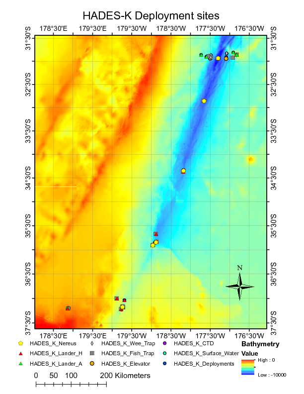
Image of NEREUS Deployment Sites. [click on the image to view a larger version]
| Funding Source | Award |
|---|---|
| NSF Division of Ocean Sciences (NSF OCE) | |
| NSF Division of Ocean Sciences (NSF OCE) | |
| NSF Division of Ocean Sciences (NSF OCE) |
[ table of contents | back to top ]