Density of purple sea urchins along the California coast, 37.8 to 39.3 N: Andrew Molean State Park to Manchester State Park from 2005-2014 (CHIPS project)
Project
| Contributors | Affiliation | Role |
|---|---|---|
| Gaylord, Brian | University of California - Davis: Bodega Marine Laboratory (UC Davis-BML) | Principal Investigator |
| Dawson, Michael N. | University of California-Merced (UC Merced) | Co-Principal Investigator |
| Grosberg, Richard K. | University of California-Davis (UC Davis) | Co-Principal Investigator |
| Jurgens, Laura J. | University of California - Davis: Bodega Marine Laboratory (UC Davis-BML) | Student, Contact |
| Schiebelhut, Lauren | University of California-Merced (UC Merced) | Student, Contact |
| Copley, Nancy | Woods Hole Oceanographic Institution (WHOI BCO-DMO) | BCO-DMO Data Manager |
Twenty accessible rocky intertidal sites were selected to span the ‘kill-zone’ and peripheral locations (see list of sites in Jurgens et al. submitted). Two rocky intertidal areas were sampled per site, usually one on either side of the point of entry onto the beach and separated by approximately 100 m. We used quadrats (1m^2 [4 * 0.25 m^2] or 0.0625 m^2) and swaths (2 m wide transects) to estimate juvenile and adult abundance for each target species.
This data set includes abundances of Strongylocentrotus purpuratus (purple sea urchin) and their burrows on transects along the California coast from 37.9 N to 39.3 N.
Access Restriction: Access to these data are restricted until publication of the associated manuscript, which is currently in review at PLOS ONE. [2015-02-05]
Related Datasets:
Henricia counts
Purple urchin density by depth
Seastar and chiton counts - quadrats and swaths
CHIPS02 - seastar chiton urchin counts in quadrats
Surveys of S. purpuratus occupancy
We quantified occupied and unoccupied burrows in intertidal bedrock; these burrows are directly attributable to S. purpuratus. The rock walls of burrows are clean while urchins occupy them, but sessile invertebrates such as barnacles, spirorbid worms and anemones rapidly (within weeks) colonize vacated burrows. We used this distinctive indicator to estimate pre-HAB urchin populations, calculating pre-HAB density as the combined density of live urchins plus clean, empty burrows. We calibrated this quantity using the average occupancy rate of burrows at four control sites (Van Damme State Park, Arena Cove, Palomarin, Duxbury Reef). We began mortality surveys at three sites (Phillips Gulch, Windermere Point, Bodega Marine Reserve) within two weeks of initial observations of an harmful algal bloom (HAB), once tides became low enough to access urchin habitat. We completed initial population surveys at the remaining sites during the first three accessible low tide series following the HAB, between October and December 2011.
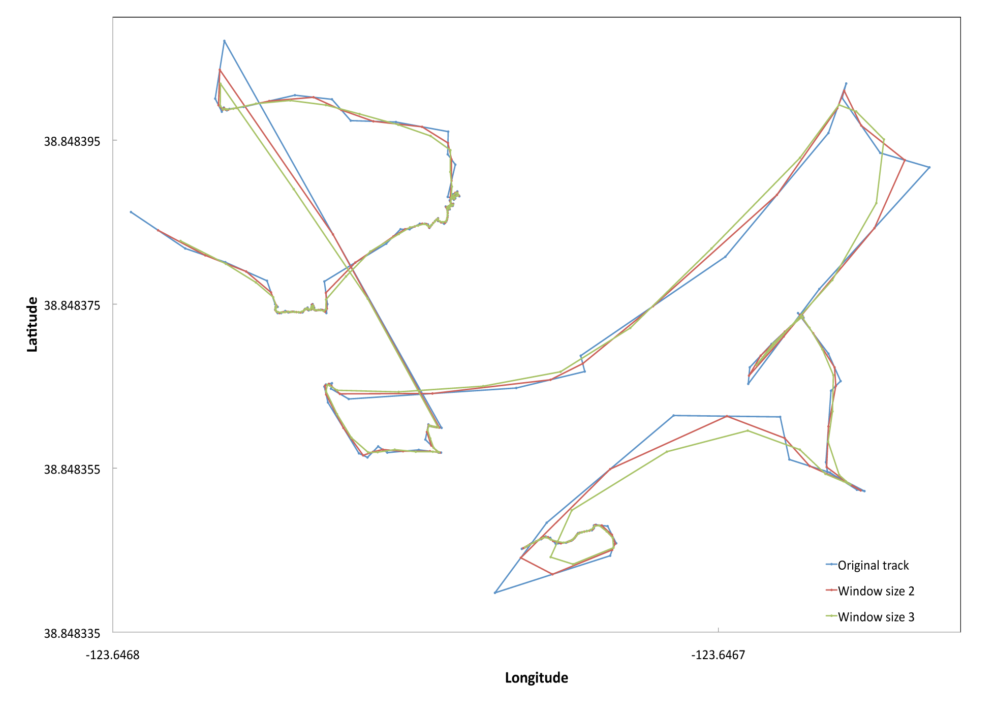
To estimate swath length we first summed the Euclidean distances between consecutive GPS trackpoints. Given the GPS had an error of +/- 3 meters we smoothed the GPS tracks by averaging across two trackpoints and then by three. We selected a window size of two with which to estimate our total transect length to adjust for the noise in our swath transects but to minimize oversmoothing. (see example figure below). We identified and removed outlying trackpoints that led to a Euclidean distance >=8 meters (likely due to temporarily poor satellite signal). The distance was then recalculated between the trackpoints immediately preceding and following the removed trackpoint. Total transect search area was calculated by multiplying the total adjusted transect length by swath width. Total transect search time was estimated using field notes and GPS waypoints and trackpoints, removing 6-second intervals where < 0.05 m were traveled (suggesting this was time during which notes were being written or tissues samples were being collected).
Swath figure: Sample GPS tracks for two transects at Iversen Point, Mendocino County. The blue line is the original unsmoothed track. The red line represents a window size of two, averaging latitudes and longitudes across each pair of consecutive trackpoints. The green line represents a window size of 3, averaging across 3 trackpoints.
BCO-DMO Processing Notes:
- added conventional header with dataset name, PI name, version date, reference information
- renamed parameters to BCO-DMO standard
- added longitude column
| File |
|---|
urchin_dens.csv (Comma Separated Values (.csv), 9.12 KB) MD5:471c1e341239c0cf0b8d758926ad96d7 Primary data file for dataset ID 541003 |
| Parameter | Description | Units |
| site | name of location surveyed | unitless |
| lat | latitude of survey site; north is positive | decimal degrees |
| lon | longitude; east is positive | decimal degrees |
| date_survey | first date quadrat-based quantitative surveys were conducted; i.e. date the data here were collected | yyyy-mm-dd |
| quad_num | number of the quadrat in which counts of live urchins and empty burrows were conducted; total of 12 | unitless |
| quad_area | area of the quadrat in which counts were conducted. Quadrats were 50cm per square side. | meter^2 |
| live_per_quad | number of live Strongylocentrotus purpuratus per quadrat | # urchins |
| live_per_m2 | number of live urchins per quadrat scaled by area of quadrat to a count per square meter | # urchins/meter^2 |
| empty_per_quad | number of clean unfouled & empty S. purpuratus burrows in each quadrat | # burrows |
| empty_per_m2 | number of empty burrows per quadrat scaled by area of quadrat to a count per meter square | # burrows/meter^2 |
| prior_density_m2 | prior density estimated using clean empty burrows per square meter plus live urchins per square meter | # urchins/meter^2 |
| impact_flag | Yes=recent loss of urchins detected; No= no evidence of recent urchin loss in the populations; in each case this assessment was based on the presence of clean empty urchin burrows versus live animals | unitless |
CalifCoast_Gaylord_CHIPS
| Website | |
| Platform | shoreside Calif_shore |
| Start Date | 2005-01-01 |
| End Date | 2014-05-15 |
| Description | Various intertidal invertebrate studies. |
Ecological & genetic recovery from a massive invertebrate die-off along the central coast of California (CHIPS)
This project is a Collaborative Research project funded by an NSF RAPID grant.
Description from NSF award abstract:
The potentially important role that larval dispersal may play in determining gene flow, distributions, and population structure of marine invertebrates remains unclear despite many hundreds of descriptive comparisons of pelagic duration and population genetic structure. This lack of clarity suggests many factors may influence population genetic structure and their interactions may be complex. Difficulties studying these factors include (under normal circumstances) distinguishing local from exogenous recruitment and therefore the true distribution of dispersal distances. For example, experiments that normally could be undertaken to explore this issue are very small scale relative to the distances that many marine taxa may disperse.
In August 2011, a large-scale natural removal experiment was initiated along a 100 km stretch of the central California coast. The PIs propose to use this rare opportunity to clarify the effects of dispersal and species interactions on marine population genetic variation and community structure. They propose to study three species that suffered very high rates of mortality: an ecosystem engineer (Strongylocentrotus purpuratus, ~100% mortality), a keystone species (Pisaster ochraceus, ~10-70% mortality), and one of its competitors (Leptasterias sp., ~100% mortality). Their objectives during this first year following the natural large-scale die-off are to:
(1) quantify the abundance and distribution of the target species at sites across the impacted range and reference sites to the south and north,
(2) develop and use genetic markers to identify the sources and dispersal distances of new recruits of P. ochraceus, Leptasterias sp., and S. purpuratus that recolonize the impacted range, and
(3) describe changes in abundance of these three species and their prey and competitors at sites throughout the impacted range.
| Funding Source | Award |
|---|---|
| NSF Division of Ocean Sciences (NSF OCE) | |
| NSF Division of Ocean Sciences (NSF OCE) |
[ table of contents | back to top ]