HADES-K - Deployment Log from R/V Thomas G. Thompson TN309 from the Kermadec Trench adjacent to New Zealand; 2014 (HADES project)
Project
| Contributors | Affiliation | Role |
|---|---|---|
| Drazen, Jeffrey C. | University of Hawai'i (UH) | Principal Investigator |
| Shank, Timothy M. | Woods Hole Oceanographic Institution (WHOI) | Principal Investigator, Contact |
| Yancey, Paul | Whitman College | Principal Investigator |
| Gegg, Stephen R. | Woods Hole Oceanographic Institution (WHOI BCO-DMO) | BCO-DMO Data Manager |
HADES-K - Deployment Log
Generated by cruise personnel
BCO-DMO Processing Notes
- Generated from original file: "HADESK_deployment_log_20140517_0325.xlsx" contributed by Tim Shank
- Parameter names edited to conform to BCO-DMO naming convention found at Choosing Parameter Name
- "nd" (no data) inserted into blank cells and cells with "-"
- Minor corrections to date/time fields (remove spaces, add a missing digit)
- Lat/Lon integer degrees and decimal minutes signed to match lat/lon decimal degrees
| File |
|---|
HADESK_DeployLog.csv (Comma Separated Values (.csv), 22.12 KB) MD5:3ce0595a8ad4e228361a64e3404b7968 Primary data file for dataset ID 626031 |
| Parameter | Description | Units |
| Deploy_No | Consecutive Deployment Number | dimensionless |
| Vehicle | Vehicle or Instrument Deployed | text |
| Site | Deployment Site | text |
| Dive_ID | Dive Id | text |
| Station | Station | dimensionless |
| Deploy_Date_Time_GMT | Date/Time of Deployment (includes date/time ranges) | YYYYMMDD_HHMM |
| Deploy_Lat | Deployment Latitude (South is Negative) | decimal degrees |
| Deploy_Lon | Deployment Longitude (West is Negative) | decimal degrees |
| Deploy_Lat_Deg | Deployment Latitude Integer Degrees (South is Negative) | degrees |
| Deploy_Lat_Min | Deployment Latitude Decimal Minutes (South is Negative) | decimal minutes |
| Deploy_Lon_Deg | Deployment Longitude Integer Degrees (West is Negative) | degrees |
| Deploy_Lon_Min | Deployment Longitude Decimal Minutes (West is Negative) | decimal minutes |
| Recovery_Date_Time_GMT | Date/Time of Recovery (includes date/time ranges) | YYYYMMDD_HHMM |
| Recovery_Lat | Recovery Latitude (South is Negative) | decimal degrees |
| Recovery_Lon | Recovery Longitude (West is Negative) | decimal degrees |
| Recovery_Lat_Deg | Recovery Latitude Integer Degrees (South is Negative) | degrees |
| Recovery_Lat_Min | Recovery Latitude Decimal Minutes (South is Negative) | decimal minutes |
| Recovery_Lon_Deg | Recovery Longitude Integer Degrees (West is Negative) | degrees |
| Recovery_Lon_Min | Recovery Longitude Decimal Minutes (West is Negative) | decimal minutes |
| Target_Depth | Target Depth | meters |
| Time_on_bottom | Time On Bottom | text |
| Depth | Depth | meters |
| Radio_Freq | Radio Frequency of Tracking Beacon on Vehicle | text |
| Notes | Notes | text |
TN309
| Website | |
| Platform | R/V Thomas G. Thompson |
| Start Date | 2014-04-10 |
| End Date | 2014-05-20 |
| Description | Original data are available from the NSF R2R data catalog |
Controls on Hadal Megafaunal Community Structure: a Systematic Examination of Pressure, Food Supply, and Topography (HADES)
Extracted from the NSF award abstract:
Severe technical challenges associated with the extremes of hydrostatic pressure have prevented major advances in hadal ecological studies, and relegated hadal systems to among the most poorly investigated habitats on Earth. Through this project, Hadal Ecosystems Studies (HADES) program, PIs will determine the composition and distribution of hadal species, the role of hadal pressures (piezolyte concentrations, enzyme function under pressure), food supply (distribution of POC with the abundance and biomass of trench organisms, and metabolic rates/energetic demand), and depth/topography (genetic divergence and spatial connectivity of populations) have on impacting deep-ocean community structure. This project will examine these factors using the world's first full-ocean depth hybrid remotely operated vehicle (HROV) in conjunction with the only full-ocean depth imaging lander (Hadal-Lander). This project will provide the first seafloor data and samples in one of the world's best, yet little known trenches- the Kermadec Trench (SW Pacific Ocean). Megafaunal community structure and the relationship between POC and benthic bacterial biomass will be examined as a function of depth and location by systematic high-definition imaging and sediment/faunal sampling transects from abyssal to full trench depths both along and perpendicular to the trench axis. Population genetic approaches will provide levels of genetic divergence and evolutionarily independent lineages to assess the role of depth and topography in trenches and their adjacent abyssal plain in promoting the formation of species. Physiological constraints will be investigated by examining in-situ respiration of selected fauna and tissue concentrations of such protein stabilizers as trimethylamine oxide (TMAO), and the structural adaptations of macromolecules.
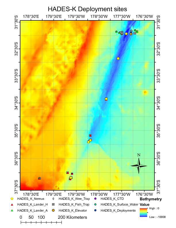
Image of NEREUS Deployment Sites. [click on the image to view a larger version]
| Funding Source | Award |
|---|---|
| NSF Division of Ocean Sciences (NSF OCE) | |
| NSF Division of Ocean Sciences (NSF OCE) | |
| NSF Division of Ocean Sciences (NSF OCE) |
[ table of contents | back to top ]