Zooplankton abundance from the western Gulf of Maine at four repeated stations from 2002-2004 from R/V Gulf Challenger GC2002-4 (REACH project)
Project
| Contributors | Affiliation | Role |
|---|---|---|
| Bucklin, Ann | University of New Hampshire (UNH/OPAL) | Principal Investigator |
| Manning, Chris | University of New Hampshire (UNH/OPAL) | Scientist |
| Allison, Dicky | Woods Hole Oceanographic Institution (WHOI BCO-DMO) | BCO-DMO Data Manager |
Time-series of zooplankton abundance data from repeat visits to four stations in the Gulf of Maine from 2002 - 2004.
Results and Methodology Descriptions can be found in:
Manning, C.A. and A. Bucklin. 2005. Multivariate analysis of the copepod community of near-shore waters in the western Gulf of Maine (Northwest Atlantic). Mar. Ecol. Prog. Ser. 292: 233-249.
| File |
|---|
allzoo.csv (Comma Separated Values (.csv), 1.94 MB) MD5:8cc5c07ecdb3265bf097264913e061ed Primary data file for dataset ID 719645 |
| Parameter | Description | Units |
| year | year | numeric |
| cruiseid | Cruise identifier | text |
| yrday | Julian day | numeric |
| date_cruiseid | Date of cruise | text |
| day | sequential sampling day | numeric |
| station | where the data was collected | station |
| lat | Station latitude; N is positive | decimal degrees |
| lon | Station longitude (West is negative) | decimal degrees |
| distance_offshore | nautical mile distance from nearest land | nm |
| net | which net collected the data | numeric |
| sample | unique identifier for collection from this net | numeric |
| depth_net_min | minimum depth of the collection | meters |
| depth_net_max | maximum depth of the collection | meters |
| depth_net_avg | numerical average depth of the collection | meters |
| temp_min | Minimum temperature | degrees Centigrade |
| temp_max | Maximum temperature | degrees Centigrade |
| temp_avg | Average temperature | degrees Centigrade |
| salt_min | Maximum salinity | dimensionless(PSU) |
| salt_max | Minimum salinity | dimensionless(PSU) |
| salt_avg | Average salinity | dimensionless(PSU) |
| volume_filtered | volume of water that flowed through the net | cubic meters |
| aliquot_dilution | fraction of catch actually counted; 1/8 to 1/1024 expressed in decimals | decimal number |
| taxon | Scientific name of zooplankton species | text |
| abundance | number of animals per cubic meter | number per cubic meter |
| Dataset-specific Instrument Name | 1/4 m MOC |
| Generic Instrument Name | MOCNESS.25 |
| Dataset-specific Description | 150 micron mesh nets.
|
| Generic Instrument Description | The Multiple Opening/Closing Net and Environmental Sensing System or MOCNESS is a family of net systems based on the Tucker Trawl principle. The MOCNESS-1/4 carries nine 1/4-m2 nets usually of 64 micrometer mesh and is used to sample the larger micro-zooplankton. |
GC2002-4
| Website | |
| Platform | R/V Gulf Challenger |
| Start Date | 2002-05-24 |
| End Date | 2004-06-28 |
| Description | This is one deployment designation for all the individual trips to the four stations of the REACH time series. The first visit was on 24 May 2002 and the last one on 28 June 2004. Methods & Sampling Hydrography, nutrients, chemistry and phytoplankton data from the western Gulf of Maine |
Regional Ecology And Coastal Hydrography (REACH)
From April 2002 through June 2004, the Regional Ecology and Coastal Hydrography (REACH) project conducted monthly field sampling in the western Gulf of Maine. REACH is one of five seed projects associated with the UNH center of excellence for Coastal Ocean Observing and Analysis (COOA).
The objective of REACH is to document and understand the functional inter-relationships among the major elements of the planktonic assemblage in the waters of western Gulf of Maine. The field program characterized the physical dynamics, nutrient availability, and phytoplankton and zooplankton assemblages. A long-term goal of this effort is to work toward a predictive index of harmful algal bloom (HAB) occurrences in near-shore waters of the western Gulf of Maine based on an integrated assessment of the planktonic community. The comprehensive nature of the study also enables this work to serve as a baseline for the western Gulf of Maine, against which future studies can be compared.
An innovative aspect of this project is the integrated analysis of the entire planktonic assemblage at the species level - including both phytoplankton and zooplankton species abundances in the same samples that are used to determine toxic dinoflagellate counts. In addition, we will ensure detailed examination and characterization of the physical oceanographic and meteorological setting from real-time data derived from satellites, remote sensors on buoys, and commercial fishing boats. (from project website)
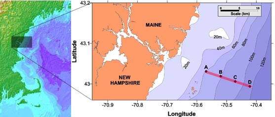
The REACH transect runs from 10km to 22km offshore of the coast of Maine and New Hampshire, USA. Sampling stations are marked by letters A, B, C, and D.
| Funding Source | Award |
|---|---|
| Coastal Ocean Observing and Analysis (COOA) |
[ table of contents | back to top ]