Salmon length, weight, sex, stomach data from F/V Great Pacific, R/V Miller Freeman multiple cruises in the Coastal Gulf of Alaska, NE Pacific from 2001-2004 (NEP project)
Project
Program
| Contributors | Affiliation | Role |
|---|---|---|
| Wertheimer, Alex C. | National Oceanic and Atmospheric Administration - Alaska Fisheries Science Center (NOAA-AFSC-Auke) | Principal Investigator |
| Cokelet, Edward D. | National Oceanic and Atmospheric Administration (NOAA-PMEL) | Co-Principal Investigator |
| Farley, Edward V. | National Oceanic and Atmospheric Administration - Alaska Fisheries Science Center (NOAA-AFSC-Auke) | Co-Principal Investigator |
| Moss, Jamal Hasan | National Oceanic and Atmospheric Administration - Alaska Fisheries Science Center (NOAA-AFSC-Auke) | Scientist, Scientist, Contact, Contact |
| Copley, Nancy | Woods Hole Oceanographic Institution (WHOI BCO-DMO) | BCO-DMO Data Manager |
Abstract
GLOBEC 2000: Factors Affecting the Distribution of Juvenile Salmon in the Gulf of Alaska
J. Helle (NMFS/AFSC, Auke Bay Laboratory)
E. D. Cokelet (Pacific Marine Environmentla Laboratory),
E. V. Farley, Jr. (NMFS/AFSC, Auke Bay Laboratory),
A. B. Hollowed (NMFS/AFSC),
P. J. Stabeno (Pacific Marine Environmental Laboratory)
"Remarkable changes in atmospheric, oceanic and biological conditions have occurred in recent decades in the North Pacific Ocean including declines in the marine survival of some salmon stocks. Fishery scientists generally agree that in the first few months after leaving freshwater, salmon survival and growth are linked to oceanic variability. The purpose of this research is to focus National Marine Fisheries Service studies on the GLOBEC region, augment oceanographic measurements and determine what biological and physical factors influence the distribution of juvenile salmon. Three general hypotheses are explored in this proposal: (1) juvenile salmon prefer the buoyancy-driven Alaska Coastal Current (ACC) at the head of the Gulf of Alaska, (2) they associate with oceanic temperature, salinity, current and prey fields, and (3) they migrate landward of Kodiak Island in the ACC rather than seaward in the Alaskan Stream. Annual, summer cruises aboard a chartered fishing vessel will catch juvenile salmon on 10 transects between Yakutat Bay and Kodiak Island. The vessel will be outfitted with a thermosalinograph to measure sea-surface temperature and salinity, and with an Acoustic Doppler Current Profiler (ADCP) - each operating continuously for fine-scale resolution. Modeled tidal currents will be removed from ADCP measurements to reveal the mean flow fields. At each trawl site, temperature and salinity profiles will provide water-column properties, and bongo-net hauls will give zooplankton distributions. Stomach samples from juvenile salmonids will be analyzed in the laboratory for diet composition and compared with zooplankton distributions. Analysis of salmon otoliths for hatchery thermal marks and Genetic Stock Identification techniques will be used to determine the home stream of hatchery and wild stocks in the Gulf of Alaska and their distribution with respect to oceanographic regimes. Retrospective analysis of catch per unit effort versus oceanographic and prey factors will reveal what affects the distribution of pink, chum, coho and sockeye salmon in the study region. Proxies for bio-physical factors will be developed and compared with salmon-run size."(project proposal)
Data Collection Details:
Types: CTD profiles, ADCP profiles of ocean current, juvenile salmonid catch statistics from trawls, salmonid stomach samples analyzed for diet composition, salmonid otolith analyses, Genetic Stock Identification, zooplankton distributions from bongo-net hauls
Platform: Chartered fishing vessel
Spatial extent: 10 transects perpendicular to the coast between Yakutat Bay and Kodiak Island
Temporal extent: ~2 weeks each July-August of 2001-2004.
Fish samples were collected with a 198-m-long mid-water rope trawl with hexagonal mesh wings and body, and a 1.2-cm mesh liner in the codend (Fig. 2, Table 1). The rope trawl was towed at 3.5 to 5 kt, at or near surface, and had a typical spread of 40-m horizontally and 14-m vertically. All tows lasted 30 minutes and covered 1.5 to 2.8 nautical miles. All fish sampling was done during daylight hours. Sometimes this meant that salmon trawls preceded CTD casts. For reference, sunrise occurred at 06:04 ADT and sunset at 22:27 ADT on 1 August 2003 at 58o N. Alaska Daylight Time (ADT) is 8 hours earlier than Greenwich Mean Time (GMT).
Station map from the GP0108 cruise report.
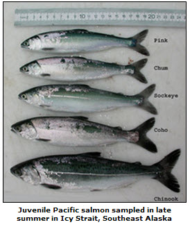
Salmon and other fishes were sorted by species and counted. Standard biological measurements including fork length, body weight and sex. Scale samples from a preferred area (to document age and growth) were taken from subsamples of all salmon species. Subsamples of juvenile pink (Oncorhynchus gorbuscha), chum (O. keta), and sockeye (O. nerka) salmon were frozen whole for laboratory analyses of food habits, otolith hatchery thermal marks (pink and chum salmon), and genetic analysis (chum salmon). Tissues and otoliths were also saved from immature and maturing chum salmon to determine stock distribution and migration of these salmon. All other fish species were counted; juvenile rockfish (Sebastes spp.) and sablefish (Anoplopoma fimbria) were frozen whole for laboratory analyses.
| File |
|---|
salmon_biodata.csv (Comma Separated Values (.csv), 2.42 MB) MD5:0c82480e92c854e1ba9a63a4eaaf4d8b Primary data file for dataset ID 3106 |
| Parameter | Description | Units |
| year | year, reported as YYYY, e.g. 1995 | dimensionless |
| day_local | day of month, local time | dimensionless |
| month_local | month of year, local time | dimensionless |
| yrday_local | Local day and decimal time, as 326.5 for the 326th day of the year, or November 22 at 1200 hours (noon). | dimensionless |
| haul_id | First four numbers represent year, second four numbers represent haul number. | dimensionless |
| sta_id | Station identification. | dimensionless |
| transect | Transect name. | dimensionless |
| lat | Latitude, in decimal degrees, North is positive, negative denotes South. | decimal degrees |
| lon | Longitude, in decimal degrees, East is positive, negative denotes West. | decimal degrees |
| depth_w | water depth | meters |
| species_common_name | common name of fish species | dimensionless |
| maturity | Status of maturity: adult (A), juvenile (J), immature (I). | dimensionless |
| length_froz | length of frozen fish from front tip to fork of tail | ? |
| length_wet | length of wet fish | ? |
| weight_froz | weight of frozen fish | grams |
| weight_wet | weight of wet fish - pre-frozen | grams |
| sex | Male (m), Female (f), Immature (i) | dimensionless |
| stomwt_full | Stomach weight while full. | grams |
| stomwt_empty | empty stomach weight | ? |
| sealice | number of parasitic sea lice found on body | dimensionless |
| comments | comments pertaining to sample | dimensionless |
| Dataset-specific Instrument Name | Midwater Trawl |
| Generic Instrument Name | Midwater Trawl |
| Dataset-specific Description | Fish samples were collected with a 198-m-long mid-water rope trawl with hexagonal mesh wings and body, and a 1.2-cm mesh liner in the codend. The rope trawl was towed at 3.5 to 5 kt, at or near surface, and had a typical spread of 40-m horizontally and 14-m vertically. |
| Generic Instrument Description | A mid-water or pelagic trawl is a net towed at a chosen depth in the water column to catch schooling fish such as herring and mackerel. Midwater trawl nets have very large front openings to herd schooling fish toward the back end where they become trapped in the narrow "broiler". The sides of the deployed net are spread horizontally with two large metal foils, called "doors," positioned in front of the net. As the trawler moves forward, the doors, and therefore the net, are forced outward, keeping the net open.
This instrument designation is used when specific make and model are not known. |
GP0108
| Website | |
| Platform | F/V Great Pacific |
| Report | |
| Start Date | 2001-07-17 |
| End Date | 2001-08-06 |
| Description | The July - August 2001 OCC/GLOBEC cruise focused on salmon (Oncorhynchus spp.), and zooplankton distribution, and physical properties (current, temperature, and salinity) along 11 transects beginning at Icy Point near northern Southeast Alaska and ending at Cape Kaguyak at the western end of Kodiak Island. Sampling along each transect occurred over the continental shelf of the Gulf of Alaska and beyond the 200-m slope and into oceanic depths. The purpose was to investigate the relationships between biological and physical oceanographic processes that affect the distribution of juvenile salmon in the coastal Gulf of Alaska.
This deployment was also known as GP0101. |
GP0207-01
| Website | |
| Platform | F/V Great Pacific |
| Report | |
| Start Date | 2002-07-11 |
| End Date | 2002-07-27 |
| Description | NEP GLOBEC gave this cruise the designation GP0207 and NOAA gave this cruise the designation GP0201. The data say 0201. The cruise report, inventory and eventlog say GP0207.
18 May 2011, dld - This cruise consisted of Leg 1 and Leg 2. Metadata is edited to reflect this information gleaned from the event log and the cruise report. The cruise report starts with a transit, not the science.
Leg 1 includes the 11-16 July 2002 transit from Dutch Harbor to Yakutat where science personnel and gear were picked up. The Leg ends on 27 July in Seward. Chief Scientist was Edward D. Cokelet.
Leg 2 departed Seward on 28 July and arrived in Dutch Harbor on 8 August with Christine Kondzela as Chief Scientist. |
GP0401-01
| Website | |
| Platform | F/V Great Pacific |
| Report | |
| Start Date | 2004-10-17 |
| End Date | 2004-10-28 |
| Description | 23 May 2011, dld - This cruise consisted of Leg 1 and Leg 2. Metadata is edited to reflect this information gleaned from the event log and the cruise report.
Leg 1 departed Dutch Harbor. The Leg ended in Kodiak. Chief Scientist was Jamal H. Moss.
Leg 2 departed Kodiak and arrived in Dutch Harbor. Chief Scientist was Edward D. Cokelet. |
MF0310
| Website | |
| Platform | R/V Miller Freeman |
| Report | |
| Start Date | 2003-07-18 |
| End Date | 2003-08-09 |
GP0207-02
| Website | |
| Platform | F/V Great Pacific |
| Report | |
| Start Date | 2002-07-28 |
| End Date | 2002-08-08 |
| Description | NEP GLOBEC gave this cruise the designation GP0207 and NOAA gave this cruise the designation GP0201. The data say 0201. The cruise report, inventory and eventlog say GP0207.
18 May 2011, dld - This cruise consisted of Leg 1 and Leg 2. Metadata is edited to reflect this information gleaned from the event log and the cruise report. The cruise report starts with a transit, not the science.
Leg 1 includes the 11-16 July 2002 transit from Dutch Harbor to Yakutat where science personnel and gear were picked up. The Leg ends on 27 July in Seward. Chief Scientist was Edward D. Cokelet.
Leg 2 departed Seward on 28 July and arrived in Dutch Harbor on 8 August with Christine Kondzela as Chief Scientist. |
GP0401-02
| Website | |
| Platform | F/V Great Pacific |
| Report | |
| Start Date | 2004-11-01 |
| End Date | 2004-11-12 |
| Description | 23 May 2011, dld - This cruise consisted of Leg 1 and Leg 2. Metadata is edited to reflect this information gleaned from the event log and the cruise report.
Leg 1 departed Dutch Harbor. The Leg ended in Kodiak. Chief Scientist was Jamal H. Moss.
Leg 2 departed Kodiak and arrived in Dutch Harbor. Chief Scientist was Edward D. Cokelet. |
U.S. GLOBEC Northeast Pacific (NEP)
Program in a Nutshell
Goal: To understand the effects of climate variability and climate change on the distribution, abundance and production of marine animals (including commercially important living marine resources) in the eastern North Pacific. To embody this understanding in diagnostic and prognostic ecosystem models, capable of capturing the ecosystem response to major climatic fluctuations.
Approach: To study the effects of past and present climate variability on the population ecology and population dynamics of marine biota and living marine resources, and to use this information as a proxy for how the ecosystems of the eastern North Pacific may respond to future global climate change. The strong temporal variability in the physical and biological signals of the NEP will be used to examine the biophysical mechanisms through which zooplankton and salmon populations respond to physical forcing and biological interactions in the coastal regions of the two gyres. Annual and interannual variability will be studied directly through long-term observations and detailed process studies; variability at longer time scales will be examined through retrospective analysis of directly measured and proxy data. Coupled biophysical models of the ecosystems of these regions will be developed and tested using the process studies and data collected from the long-term observation programs, then further tested and improved by hindcasting selected retrospective data series.
U.S. GLOBal ocean ECosystems dynamics (U.S. GLOBEC)
U.S. GLOBEC (GLOBal ocean ECosystems dynamics) is a research program organized by oceanographers and fisheries scientists to address the question of how global climate change may affect the abundance and production of animals in the sea.
The U.S. GLOBEC Program currently had major research efforts underway in the Georges Bank / Northwest Atlantic Region, and the Northeast Pacific (with components in the California Current and in the Coastal Gulf of Alaska). U.S. GLOBEC was a major contributor to International GLOBEC efforts in the Southern Ocean and Western Antarctic Peninsula (WAP).
| Funding Source | Award |
|---|---|
| NSF Division of Ocean Sciences (NSF OCE) | |
| National Oceanic and Atmospheric Administration (NOAA) |
[ table of contents | back to top ]