Position and time data along the track of Biofloat 48 in the subpolar North Atlantic and Iceland Basin in 2008 (NAB 2008 project)
Project
Program
| Contributors | Affiliation | Role |
|---|---|---|
| D'Asaro, Eric | University of Washington Applied Physics Laboratory (UW APL) | Principal Investigator |
| Rehm, Eric | University of Washington Applied Physics Laboratory (UW APL) | Contact |
| McKee, Theresa | Woods Hole Oceanographic Institution (WHOI BCO-DMO) | BCO-DMO Data Manager |
Position and time data along Biofloat 48 track
Biofloat track is created from the raw GPS data acquired during float surfacings. The first GPS position acquired at surfacing is reporting except during long surfacings (at deployment), when a mean surface position is reported.
| File |
|---|
Biofloat_48_track.csv (Comma Separated Values (.csv), 10.09 KB) MD5:6bf2bdd89f31045f3060b8ca6295f0cc Primary data file for dataset ID 3435 |
| Parameter | Description | Units |
| latitude | latitude | degrees |
| longitude | longitude | degrees |
| julian_day_yr0 | julian day | decimal days since Jan 0 0000 |
| date | date | YYYYMMDD |
| time | time | HHMM |
| cruise | cruise identifier | dimensionless |
| Dataset-specific Instrument Name | Global Positioning System Receiver |
| Generic Instrument Name | Global Positioning System Receiver |
| Generic Instrument Description | The Global Positioning System (GPS) is a U.S. space-based radionavigation system that provides reliable positioning, navigation, and timing services to civilian users on a continuous worldwide basis. The U.S. Air Force develops, maintains, and operates the space and control segments of the NAVSTAR GPS transmitter system. Ships use a variety of receivers (e.g. Trimble and Ashtech) to interpret the GPS signal and determine accurate latitude and longitude. |
| Dataset-specific Instrument Name | Lagrangian Float |
| Generic Instrument Name | Lagrangian Float |
| Dataset-specific Description | The 2008 North Atlantic Bloom Experiment (NAB08) employed a “Lagrangian float”, custom built at the University of Washington Applied Physics Laboratory. (D’Asaro, 2003, Performance of Lagrangian Floats, Journal of Atmospheric and Oceanic Technology, Vol. 20, 896-911). |
| Generic Instrument Description | Built at the University of Washington Applied Physics Laboratory, the Lagrangian Float is not an ARGO float. It is primarily designed to accurately follow the three-dimensional motion of water parcels within the mixed layer, through a combination of neutral buoyancy and high drag provided by a one meter diameter black drogue. Typical buoyancies of a few grams result in vertical velocities relative to the water of a few mm/s, small compared to the cm/s turbulent velocities in the mixed layer. The float’s motion within the mixed layer thus closely imitates that of a planktonic organism. The float can also profile vertically. It sends data and receives commands using the Iridium satellite system. The float is designed to accommodate a wide variety of sensors. |
Biofloat_48
| Website | |
| Platform | Biofloat 48 |
| Start Date | 2008-04-04 |
| End Date | 2008-05-25 |
| Description | See document NAB08Float48SamplingMethodologyV1.pdf for complete information on Biofloat 48's modes, cycles, and sampling intervals for each sensor. BioFloat 48 was a Lagrangian float deployed during cruise B4-2008 of the vessel R/S Bjarni Saemundsson. |
North Atlantic Bloom Experiment 2008 (NAB 2008)
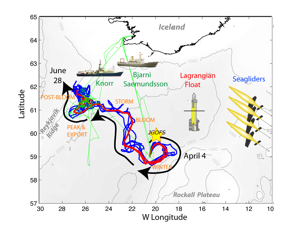
NAB2008 was a process experiment designed to study an important component of the oceanic carbon system - the North Atlantic spring bloom. The phytoplankton bloom occurring each spring in the North Atlantic, drives the uptake of carbon dioxide and is an important component of the biological pump (Bagniewski et al., 2010). Previous studies in this region have shown the importance of small temporal and spatial scales, i.e. ecosystem patchiness, during the bloom, but were restricted by the limitations of ship-based sampling. Recent advances in autonomous platforms and sensors presented an opportunity to study this important event in a new way. In addition to deployment of a diverse suite of in situ sampling devices, NAB2008 was also a test-bed for developing the strategies and knowledge needed to successfully use new methods to drive the next generation of ocean observations.
In 2008, a coordinated deployment of 1 float, 4 Seagliders and 2 research vessels sampled the evolution of the North Atlantic spring bloom along and surrounding the nearly Lagrangian path followed by the float. The autonomous measurements were continuous through the experimental period, and included CTD, chlorophyll fluorescence, optical backscatter, and oxygen on all platforms; and nitrate, optical attenuation, and various radiance measurements on the float. Velocities were determined from the vehicle motion, with the float extending to a depth of 230 meters and gliders to 1,000 meters. The autonomous vehicles were deployed, rescued, and recovered on three cruises of the Icelandic vessel Bjarni Saemundsson. A 21-day cruise of the R/V Knorr conducted more detailed measurements during the peak of the bloom in May. The R/V Knorr sampling program included optical profiles, ADCP data and analysis of water samples for nutrients, particulate organic carbon, pigments, micro-plankton composition, complemented by guest investigator analyses. Data from both ships were used to calibrate and validate the autonomous measurements.
References:
Bagniewski, W., Fennel, K., Perry, M. J., and D'Asaro, E. A. (2010) Optimizing models of the North Atlantic spring bloom using physical, chemical and bio-optical observations from a Lagrangian float, Biogeosciences Discuss., 7, pp. 8477-8520, doi:10.5194/bgd-7-8477-2010
Click on image to view full size
Ocean Carbon and Biogeochemistry (OCB)
The Ocean Carbon and Biogeochemistry (OCB) program focuses on the ocean's role as a component of the global Earth system, bringing together research in geochemistry, ocean physics, and ecology that inform on and advance our understanding of ocean biogeochemistry. The overall program goals are to promote, plan, and coordinate collaborative, multidisciplinary research opportunities within the U.S. research community and with international partners. Important OCB-related activities currently include: the Ocean Carbon and Climate Change (OCCC) and the North American Carbon Program (NACP); U.S. contributions to IMBER, SOLAS, CARBOOCEAN; and numerous U.S. single-investigator and medium-size research projects funded by U.S. federal agencies including NASA, NOAA, and NSF.
The scientific mission of OCB is to study the evolving role of the ocean in the global carbon cycle, in the face of environmental variability and change through studies of marine biogeochemical cycles and associated ecosystems.
The overarching OCB science themes include improved understanding and prediction of: 1) oceanic uptake and release of atmospheric CO2 and other greenhouse gases and 2) environmental sensitivities of biogeochemical cycles, marine ecosystems, and interactions between the two.
The OCB Research Priorities (updated January 2012) include: ocean acidification; terrestrial/coastal carbon fluxes and exchanges; climate sensitivities of and change in ecosystem structure and associated impacts on biogeochemical cycles; mesopelagic ecological and biogeochemical interactions; benthic-pelagic feedbacks on biogeochemical cycles; ocean carbon uptake and storage; and expanding low-oxygen conditions in the coastal and open oceans.
| Funding Source | Award |
|---|---|
| NSF Division of Ocean Sciences (NSF OCE) | |
| NSF Division of Ocean Sciences (NSF OCE) |
[ table of contents | back to top ]