Benthic cover quadrat observations and photos from the West coast of Leyte, the Philippines in the municipalities of Albuera and Bay Bay City, 2014-2017
Project
| Contributors | Affiliation | Role |
|---|---|---|
| Pinsky, Malin | Rutgers University | Principal Investigator |
| Stuart, Michelle | Rutgers University | Co-Principal Investigator |
| York, Amber D. | Woods Hole Oceanographic Institution (WHOI BCO-DMO) | BCO-DMO Data Manager |
Abstract
Example quadrat photo. See "Data Files" section to access the full set of quadrat photos bundled in zip files by year.
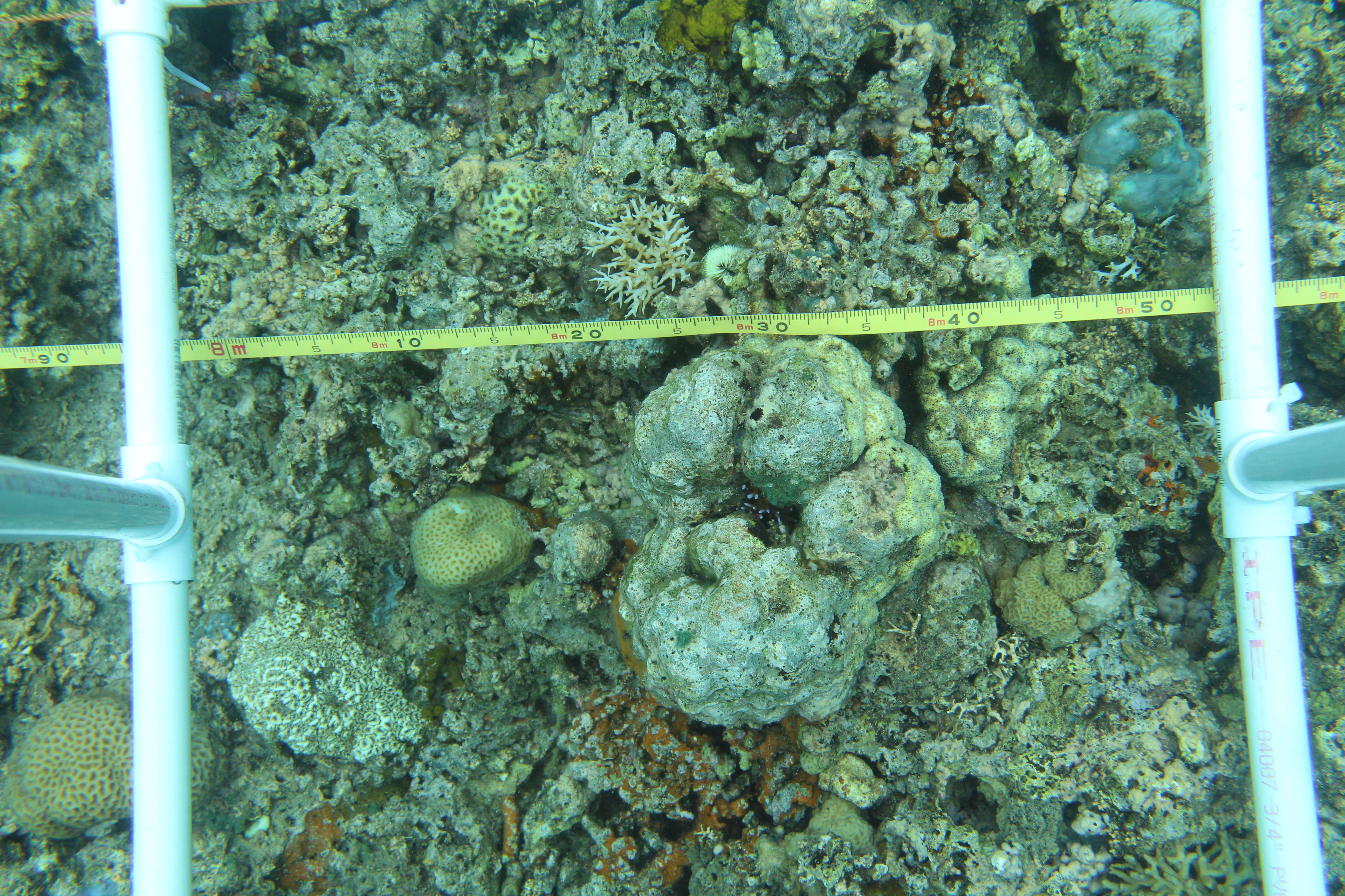
[Example image IMG_1603.JPG is also included in the file bundle 2014_quadrat_photos.zip]
See Related Datasets and Supplemental Files sections for other data collected as part of the same transect and quadrat surveys.
Photoquadrat framer constructed from PVC pipe, PVC cement, galvanized bolts, wing nuts, and washers. Quadrat was 50 x 50 cm.
Benthic quadrat procedure:
- records dive and transect attributes:
- dive number
- transect number
- site name
- date
- time
- observer initials
- visibility (meters)
- depth at start of transect (feet)
- depth at end of transect (feet)
- transect length (meters)
- quadrat number
- places 5 quadrats in fixed or random locations along transect
- random locations were selected prior to the start of the transect
- fixed locations were returned to each year
- nails were driven into the reef the first year to mark locations
- observes and records the primary benthic cover within the quadrat
- family of invertebrate or abiotic benthic cover
- measures rugosity within the quadrat using the chain method. Rugosity was measured with a 6 m chain. (See EPA Field Manual for Coral Reef Assessments, Santavy et al. (2012).
- records any additional notes
- takes photo and records photo file number
Issue report:
Some photos could not be taken if the reef was too shallow and the camera was above water.
BCO-DMO Data Manager Processing notes:
* Imported data tables each sheet named "Quadrats" within files submitted to BCO-DMO as Transect_and_quadrat_data/GPSSurveys.*.xlsx
* Supplemental transect locations table from Transect_locations/Transect_locations.*.xlsx concatenated together and attached to this dataset and Fish and Invertebrate Transects dataset as a supplemental file. See file description for details about one location lat/lon that was updated based on a comment in the file.
* replaced semicolons in time values to colons to match the rest of the time format.
* Column Image_nums listed file image numbers delimited with either a space, comma, or comma and space. Changed to semicolon delimiter for consistency.
* Date format changed to ISO 8601 format YYYY-MM-DD
* Column ISO_DateTime_UTC added to data table from local dates and times.
* Dataset contains variable missing data identifiers (blank,?,X, and a period alone in a cell). These were left as-is though the difference is unknown.
| File |
|---|
Quadrat Photos 2014 filename: 2014_quadrat_photos.zip (ZIP Archive (ZIP), 5.39 GB) MD5:a17f45f0ade4515ac88bbd4fb00295ee Quadrat photos from 2014. See benthic cover data table for data quantified from these images. |
Quadrat Photos 2015 part 1 (Jan-Feb) filename: 2015_01_quadrat_photos.zip (ZIP Archive (ZIP), 1.04 GB) MD5:81fa2ea8e5a9cd64045a24778135c711 Quadrat photos from January and February of 2015. See benthic cover data table for data quantified from these images. |
Quadrat Photos 2015 part 2 (June) filename: 2015_05_quadrat_photos.zip (ZIP Archive (ZIP), 1.49 GB) MD5:04b0f03302a270250255adf96f3d3713 Quadrat photos from June 6th to 20th, 2015. See benthic cover data table for data quantified from these images. |
Quadrat Photos 2016 filename: 2016_quadrat_photos.zip (ZIP Archive (ZIP), 374.85 MB) MD5:cd35a6d108ad126f62c700fd9547f508 Quadrat photos from 2016. See benthic cover data table for data quantified from these images. |
Quadrat Photos 2017 filename: 2017_quadrat_photos.zip (ZIP Archive (ZIP), 3.31 GB) MD5:a4fb740294fce39fcf0b8057ffd11e03 Quadrat photos from 2017. See benthic cover data table for data quantified from these images. |
benthic_cover.csv (Comma Separated Values (.csv), 74.47 KB) MD5:574ff29ad4c68f7580495352adbc6505 Primary data file for dataset ID 862410 |
| File |
|---|
Example Quadrat Photo filename: IMG_1603.JPG (JPEG Image (.jpg), 9.97 MB) MD5:49a3a39707e27b721daababe26408aaf Example quadrat photo. This image is included along with the other quadrat photos bundled in zip files which can be downloaded from the "Data Files" section. |
Transect and quadrat locations filename: transect_locations.csv (Comma Separated Values (.csv), 51.60 KB) MD5:668c935737d5d7021dda620c2f7dea32 Transect and quadrat information. Lat/lon points are usually the southern edge of the transect.
Parameters (column name, description, and units):
survey_season = year of survey season
site = site name
Type = type (Fixed or Random)
direction= Direction (e.g. NE for North East)
Waypoint Name =Waypoint name (e.g. Cabatoan F1 real)
lat = latitude in decimal degrees
lon = longitude in decimal degrees
Quadrat_Number = Quadrat number
Quadrat_Depth = Quadrat depth
Note = Note
This table was imported from multiple Excel files and concatenated into one table. Table was transformed from multiple quadrant depth columns to Quadrat_Number and Quadrat_Depth columns. One of the original excel files (Transect_locations2016_05.xlsx) had a note "Moved Fixed 2 because it was too shallow - 10.76399, 124.78524." Since the strikethrough formatting isn't preserved in the data tables BCODMO imports, the values in the lat/lon columns were updated to use the new values provided in the comment. |
Relationship Description: Data from the same dives.
Relationship Description: Data from the same transects.
| Parameter | Description | Units |
| DiveNum | Dive Number | unitless |
| TransectNum | Transect number | unitless |
| Site | Site name (fixed (permanent) or random indicated by a P or R, respectively) | unitless |
| Date | Date of dive (local time zone UTC+08:00) | unitless |
| Time | Time of dive (local time zone UTC+08:00) | unitless |
| Observer | observer initials (First_Last) | unitless |
| Vis_m | Visibility | meters (m) |
| Heading | compass orientation travelled on the transect. degrees (0-360) | degrees |
| Depth_start_ft | depth at start of transect | feet |
| Depth_end_ft | depth at end of transect | feet |
| Length_m | transect length | meters (m) |
| Quadrat_num | order of quadrat placed | unitless |
| Position_m | position along the transect length | meters (m) |
| Cover_1 | Primary cover #1 within the quadrat. A period symbol "." in this column indicates there was no coral. A question mark indicates "could not determine." Columns Cover_1,Cover_2,Cover_3,Cover_4,Cover_5 represent the dominant cover types (up to five) within the quadrat. | unitless |
| Cover_2 | Primary cover #2 within the quadrat. A period symbol "." in this column indicates there was no coral. A question mark indicates "could not determine." Columns Cover_1,Cover_2,Cover_3,Cover_4,Cover_5 represent the dominant cover types (up to five) within the quadrat. | unitless |
| Cover_3 | Primary cover #3 within the quadrat. A period symbol "." in this column indicates there was no coral. A question mark indicates "could not determine." Columns Cover_1,Cover_2,Cover_3,Cover_4,Cover_5 represent the dominant cover types (up to five) within the quadrat. | unitless |
| Cover_4 | Primary cover #4 within the quadrat. A period symbol "." in this column indicates there was no coral. A question mark indicates "could not determine." Columns Cover_1,Cover_2,Cover_3,Cover_4,Cover_5 represent the dominant cover types (up to five) within the quadrat. | unitless |
| Cover_5 | Primary cover #5 within the quadrat. A period symbol "." in this column indicates there was no coral. A question mark indicates "could not determine." Columns Cover_1,Cover_2,Cover_3,Cover_4,Cover_5 represent the dominant cover types (up to five) within the quadrat. | unitless |
| Rugosity_m | rugosity along transect. An X in the rugosity column means rugosity was not recorded at that station. | meters (m) |
| Notes | transect notes | unitless |
| Image_nums | image file number | unitless |
| ISO_DateTime_UTC | Timestamp with timezone in ISO 8601 format (UTC) | unitless |
| Dataset-specific Instrument Name | Canon Rebel T5i |
| Generic Instrument Name | Underwater Camera |
| Dataset-specific Description | Waterproof Camera: Canon Rebel T5i with an EF-S 18-55mm lens. |
| Generic Instrument Description | All types of photographic equipment that may be deployed underwater including stills, video, film and digital systems. |
RAPID: Mega-typhoon impacts on the metapopulation resilience of coral reef fishes (Reef Fish Resilience)
Description from NSF award abstract:
When Typhoon Haiyan hit the Philippines it had sustained winds of 305 to 315 kph and was the strongest storm ever to make landfall. Storms are one of the most important disturbances to coral reef ecosystems. Previous research has primarily emphasized that habitat recovery is important for the recovery of reef fish communities after disturbance. We understand little, however, about the role of larval dispersal in mediating species responses to disturbance. Reef fish function as metapopulations connected by larval dispersal among reefs, and larval connectivity is therefore a critical process for their dynamics. A field site directly in Typhoon Haiyan's path provides an ideal opportunity to address the role of larval dispersal during recovery. Over the course of four field seasons (2008 to 2013), nearly two thousand clownfish were surveyed along 20km of coastline. Clownfish possess the same basic life history as most reef fish (sedentary adults and pelagic larvae), but are sufficiently rare and visible that genetic parentage methods can be used to follow larval dispersal. This study site is therefore a unique location in which to understand the metapopulation impacts of a massive storm. This project will focus on three hypotheses: 1) Habitat destruction determines the short-term impacts of storms disturbance, 2) Metapopulation processes shape recolonization after disturbance, and 3) Disturbance allows rare competitors to increase in abundance. The project will address these questions with a combination of fixed and random transects to assess reef habitat and reef fish abundance and diversity, as well as detailed, spatially explicit surveys of anemones and clownfish. Genetic mark-recapture and parentage methods with yellowtail clownfish will pinpoint the origin of new recruits that recolonize the reef post-typhoon.
| Funding Source | Award |
|---|---|
| NSF Division of Ocean Sciences (NSF OCE) |
[ table of contents | back to top ]